DISTRICT DIVISIONS

1. South East district
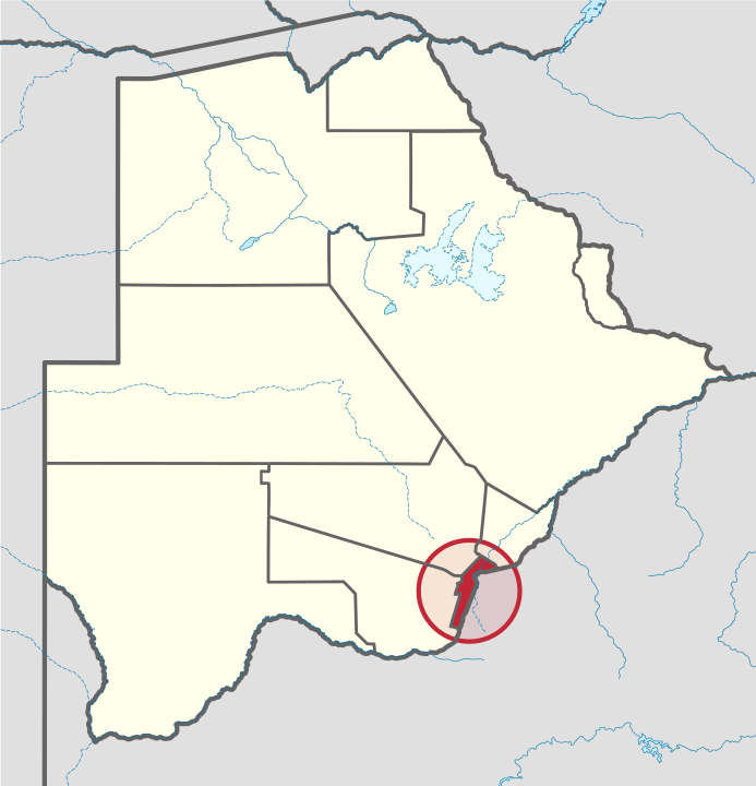
The capital city of Botswana, Gaborone, is surrounded by this district. The administrative capital for the South-East district is the village of Ramotswa. In the southeast, South-East borders the North West Province of South Africa. Domestically, it borders Kgatleng in northeast, Kweneng in northwest, Southern in southwest. As of 2011, the total population of the district was 85,014 compared to 60,623 in 2001. The growth rate of population during the decade was 3.44. The total number of workers constituted 21,810 with 11,927 males and 9,883 females, with a majority of them involved in agriculture. The district is administered by a district administration and district council which are responsible for local administration.
Geography
In the southeast, South-East borders the North West Province of South Africa. Domestically, it borders Kgatleng in northeast, Kweneng in northwest, Southern in southwest. Most part of Botswana has tableland slopes sliding from east to west. The region has an average elevation of around 915 m (3,002 ft) above the mean sea level. The vegetation type is Savannah, with tall grasses, bushes and trees. The annual precipitation is around 65 cm (26 in), most of which is received during the summer season from November to May. Most of the rivers in the region are seasonal, with Limpopo River, which are prone to flash floods, being the most prominent. Mokolodi Nature Reserve, Gaborone Game Reserve and Manyelanong Game Reserve are the major tourist places in the district.
Demographics
As of 2011, the total population of the district was 85,014 compared to 60,623 in 2001. The growth rate of population during the decade was 3.44. The population in the district was 4.20 per cent of the total population in the country. The sex ratio stood at 91.83 for every 100 males, compared to 92.49 in 2001. The average house hold size was 2.51 in 2011 compared to 4.05 in 2001. There were 4,309 craft and related workers, 2,505 clerks, 5,115 people working in elementary occupation 884 Legislators, Administrators & managers 1,650 Plant & machine operators and assemblers, 1,215 professionals, 2,438 service workers, shop & market sales workers, 464 skilled agricultural & related workers 1,708 technicians and associated professionals, making the total work force to 20,481.
Education and Economy
As of 2011, there were a total of 67 schools in the district, with 31.70 per cent private schools. The total number of students in the Council schools was 28,479, while it was 8,383 in private schools. The total number of students enrolled in the district was 36,862: 18,387 girls and 18,475 boys. The total number of qualified teachers was 1,603, 1,303 female and 300 male. There were around 4 temporary teachers, 1 male and 5 female. There were 13 untrained teachers in the district. As of 2006, 4,819 were involved in agriculture, 1,091 in construction, 3,182 in education, 304 in electricity and water, 356 in finance, 446 in health, 470 in hotels and restaurants, 2,674 in manufacturing, 164 in mining and quarrying, 567 in other community services, 461 in private households, 1,922 in public administration, 1,501 in real estate, 992 in transport and communications, 2,861 in wholesale and retail trade. The total number of workers was 21,810, 11,927 male and 9,883 female.
Administration
Botswana gained independence from the British in 1966 and adapted the colonial administration framework to form its district administration. The policies were modified during 1970-74 to address some of the basic issues. The district is administered by a district administration and district council which are responsible for local administration. The policies for the administration are framed by the Ministry of Local Government. The major activities of the council are Tribal Administration, Remote Area Development and Local Governance. The executive powers of the council are vested on a commissioner appointed by the central government. Technical services wing of the Department of Local Government is responsible for developing roads, infrastructure in villages like water supply, schools and recreational facilities. All the staff of the local administration expect District Administration are selected via Unified Local Government Services (ULGS) and the Ministry of Local Government is responsible for their training, deployment and career development. The sub-districts of South-East District created as a part of National Development Plan of the district are Ramotswa and Tlokweng. In the 2011 Census the following villages were listed under each sub-district:
- Ramotswa sub-district: Mogobane, Ramotswa, Ramotswa Station/Taung
- Tlokweng sub-district: Otse, Tlokweng
[1]
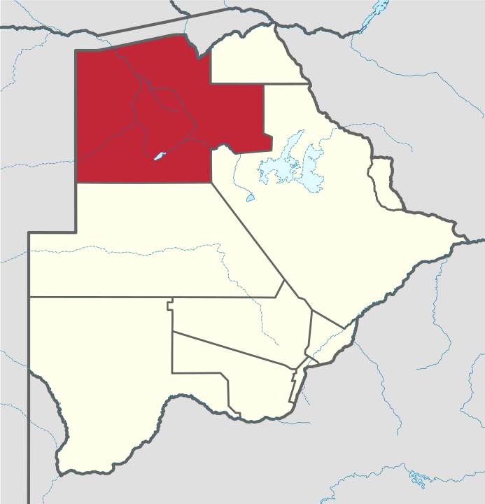
2. Kweneng District
Kweneng is the recent historical homeland of the Bakwena people, the first group in Botswana converted to Christianity by famed missionary David Livingstone. Various landmarks, including Livingstone's Cave, allude to this history. The seat of the district's government is Molepolole, Botswana's most populous village (only trailing Botswana's two cities: Gaborone and Francistown). It borders Central District in northeast, Kgatleng District on the east, South-East District in southeast, Southern District in south, Kgalagadi District in the west, Ghanzi District in the north. The district is administered by a district administration and district council which are responsible for local administration. Manyana rock paintings in Manyana village and Kgosi Sechele I Museum are the major attractions in the district. As of 2011, the total population of the district was 304,549 compared to 230,335 in 2001. The growth rate of population during the decade was 2.83. As of 2006, the total number of people working in Kweneng East in agricultural sector was 7,212, 4,727 male and 2,484 female, with agriculture being the major profession. Kweneng District has two sub-districts namely Kweneng East and Kweneng West.
Geography
Kweneng is the only district without a foreign border. It borders Central District in northeast, Kgatleng District on the east, South-East District in southeast, Southern District in south, Kgalagadi District in the west, Ghanzi District in the north. The region is traversed by the northwesterly line of equal latitude and longitude. Most part of Botswana has tableland slopes sliding from east to west. The region has an average elevation of around 915 m (3,002 ft) above the mean sea level. The vegetation type is Savannah, with tall grasses, bushes and trees. The annual precipitation is around 25 cm (9.8 in), most of which is received during the summer season from November to May. Most of the rivers in the region are seasonal, with Metsimotlhabe River, which are prone to flash floods, being the most prominent. Manyana rock paintings in Manyana village and Kgosi Sechele I Museum are the major attractions in the district.
Demographics
As of 2011, the total population of the district was 304,549 compared to 230,335 in 2001. The growth rate of population during the decade was 2.83. The population in the district was 15.04 per cent of the total population in the country. The sex ratio stood at 96.53 for every 100 males, compared to 93.90 in 2001. The average house hold size was 2.86 in 2011 compared to 4.34 in 2001. There were 11,142 craft and related workers, 4,692 clerks, 14,054 people working in elementary occupation 1,263 Legislators, Administrators & managers 6,378 Plant & machine operators and assemblers, 1,790 professionals, 7,227 service workers, shop & market sales workers, 2,988 skilled agricultural & related workers 4,125 technicians and associated professionals, making the total work force to 54,176.
Education and Economy
As of 2011, there were a total of 101 schools in the district, with 16.70 per cent private schools. The total number of students in the Council schools was 43,930 while it was 3,646 in private schools. The total number os students enrolled in the district was 47,576 constituting 23,121 girls and 24,455 boys. The total number of qualified teachers was 1,849 with 1,449 females and 400 males. There were around 094 temporary teachers, 46 male and 140 female. There were a total of 6 untrained teachers in the district. As of 2006, the total number of people working in Kweneng East in the agricultural sector was 12,740, 7,786 male and 4,954 female. There were 3,314 people in construction industry, 4,141 in education, 178 in electricity and water, 557 in finance, 531 in foreign mission, 269 in health industry, 2,088 in hotels and restaurants, 200 in local government, 578 in manufacturing, 1,358 in mining & quarrying 2,503 in other community services, 858 in private households, 504 in public administration, 6,142 in real estate, 25,969 in transport and communication industry and 2,484 wholesale industries. The total working population was 7,212 with 706 males and 296 females. As of 2006, the total number of people working in Kweneng East in the agricultural sector was 7,212, 4,727 male and 2,484 female. There were 1,001 people in construction industry, 164 in education, 073 in electricity and water, 073 in finance, 250 in foreign mission, 228 in health industry, 064 in hotels and restaurants, 648 in local government, 11,963 in manufacturing, 5,309 in mining & quarrying 918 in other community services, 125 in private households, 45 in public administration, 458 in real estate, 756 in transport and communication industry and 435 wholesale industries. The total working population was 756 with 184 males and 219 females.
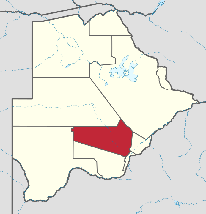
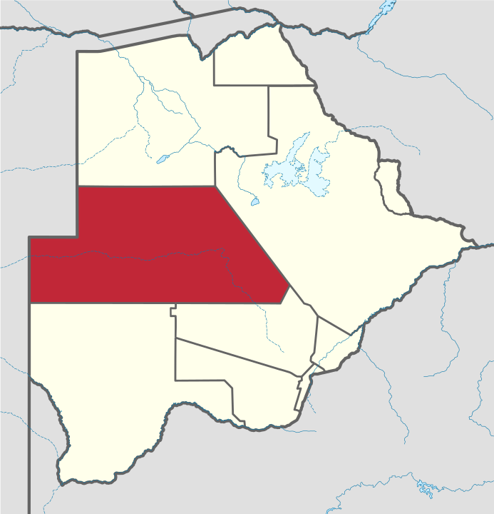
[2]3. Southern District
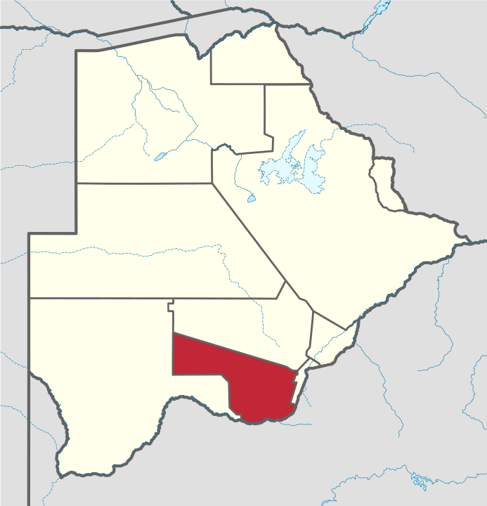
The capital of Southern district (Ngwaketse district) is Kanye, home to the Bangwaketse, one of the largest growing villages in Botswana. The Southern district (Ngwaketse district), is home to Botswana’s second largest beef farmers where there are large privately owned ranges, and several government run beef ranges which provide agricultural support to the local farmers. Maize and sorghum, Botswana’s staple crop, are also raised in the area. Southern district is where the third diamond mine of Botswana was found (the Jwaneng diamond mine), which buoys Botswana’s economic state of prosperity. It was the first district to house the capital city before being moved to Gaborone after independence. In the south, Southern borders the North West Province of South Africa. Domestically, it borders South-East District in east, Kweneng District in north, Kgalagadi District and south west. As of 2011, the total population of the district was 197,767 compared to 171,652 in 2001. The growth rate of population during the decade was 1.43. The total number of workers constituted 51,187 with 29,043 males and 22,141 females, with a majority involved in agriculture. The district is administered by a district administration and district council which are responsible for local administration.
Geography
In the south, Southern borders the North West Province of South Africa. Domestically, it borders South-East District in east, Kweneng District in north, Kgalagadi District and south west. Southern District is traversed by the northwesterly line of equal latitude and longitude. Most part of Botswana has tableland slopes sliding from east to west. The region has an average elevation of around 915 m (3,002 ft) above the mean sea level. The vegetation type is Savannah, with tall grasses, bushes and trees. The annual precipitation is around 65 cm (26 in), most of which is received during the summer season from November to May. Most of the rivers in the region are seasonal prone to flash floods. Southern district is where the third diamond mine of Botswana was found (the Jwaneng diamond mine), which drives Botswana’s economic state of prosperity.
Demographics
As of 2011, the total population of the district was 197,767 compared to 171,652 in 2001. The growth rate of population during the decade was 1.43. The population in the district was 9.77 per cent of the total population in the country. The sex ratio stood at 93.97 for every 100 males, compared to 92.25 in 2001. The average house hold size was 3.51 in 2011 compared to 4.60 in 2001. There were 5,405 craft and related workers, 1,656 clerks, 11,018 people working in elementary occupation 724 legislators, administrators and managers 2,069 plant and machine operators and assemblers, 1,195 professionals, 3,820 service workers, shop and market sales workers, 3,646 skilled agricultural and related workers, and 2,705 technicians and associated professionals, making the total work force 32,431.
Education and Economy
As of 2011, there were a total of 128 schools in the district, with 8.30 per cent private schools. The total number of students in the Council schools was 40,973, while it was 1,602 in private schools. The total number of students enrolled in the district was 42,575: 20,704 girls and 21,871 boys. The total number of qualified teachers was 1,819, 1,370 female and 449 male. There were around 73 temporary teachers, 41 male and 114 female. There were 2 untrained teachers in the district. As of 2006, 18,751 were involved in Agriculture, 1,832 in Construction, 5,042 in Education, 304 in Electricity & Water, 399 in Finance, 1,339 in Health, 1,082 in Hotels & Restaurants, 4,059 in Manufacturing, 373 in Mining and Quarrying, 1,012 in Other Community Services, 1,758 in Private Households, 4,635 in Public Administration, 2,480 in Real Estate, 1,399 in Transport & Communications6,722 in Wholesale & Retail Trade. The total number of workers constituted 51,187 with 29,043 males and 22,141 females
Administration
The sub-districts of Southern District created as a part of National Development Plan of the district are Barolong, Ngwaketse and Ngwaketse West. In the 2011 Census the following villages were listed under each sub-district: Barolong sub-district: Bethel, Borobadilepe, Digawana, Dikhukhung, Dinatshana, Ditlharapa, Gamajalela, Gathwane, Good Hope, Hebron, Kangwe, Kgoro, Lejwana, Leporung, Logagane, Lorwana, Mabule, Madingwana, Magoriapitse, Makokwe, Malokaganyane, Marojane, Metlobo, Metlojane, Mmakgori, Mmathethe, Mogojogojo, Mogwalale, Mokatako, Mokgomane, Molete, Motsentshe, Musi, Ngwatsau, Papatlo, Phihitshwane, Pitsana-Potokwe, Pitsane Siding, Pitshane Molopo, Rakhuna, Ramatlabama, Sedibeng, Sekhutlane, Sheep Farm, Tlhareseleele, Tshidilamolomo, Tswaaneng, Tswagare/Lothoje/Lokalana and Tswanyaneng Ngwaketse sub-district: Betesankwe, Diabo, Dipotsana, Gasita, Kanye, Kgomokasitwa, Lefoko, Lekgolobotlo, Lorolwana, Lotlhakane, Lotlhakane West, Magotlhwane, Manyana, Maokane, Mogonye, Mokhomba, Molapowabojang, Moshaneng, Moshupa, Ntlhantlhe, Pitseng, Ralekgetho, Ranaka, Segwagwa, Seherelela, Selokolela, Semane, Sese, Sesung, Tlhankane, Tshwaane and Tsonyane Ngwaketse West sub-district: Itholoke, Kanaku, Keng, Khakhea, Khonkhwa, Kokong, Kutuku, Mabutsane, Mahotshwane, Morwamosu, Sekoma [3]
4. Central
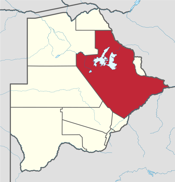
Central is the largest of Botswana's districts in terms of area and population. It encompasses the traditional homeland of the Bamangwato people. Some of the most politically connected Batswana have come from the Central District, including former President Sir Seretse Khama, former President Festus Mogae, and current President Lt. General Seretse Ian Khama. The district borders the Botswanan districts of Chobe in the north, North-West in the northwest, Ghanzi in the west, Kweneng in southwest, Kgatleng in the south and North-East in the northeast, as well as Zimbabwe also in the northeast (Matabeleland North and Matabeleland South Provinces) and South Africa in the southeast (Limpopo Province). As of 2011, the total population of the district was 576,064 compared to 501,381 in 2001. The growth rate of population during the decade was 1.40. The population in the district was 28.45 per cent of the total population in the country. Main population centers in Central include Palapye and Serowe, two of Africa's largest traditional villages. The district also contains tributaries of the Limpopo River, which are prone to flash floods when sudden rainstorms drain eastward into the Limpopo. The district is administered by a district administration and district council which are responsible for local administration. The total number of workers constituted 186,943 with 95,717 males and 91,221 females, with a majority working in transport and communication sector. The six sub-districts of Central District created as a part of National Development Plan of the district are Bobonong, Boteti, Mahalapye, Orapa, Serowe Palapye and Tutume.
Geography
In the northeast, Central borders Zimbabwe's Matabeleland North and Matabeleland South Provinces, and in the southeast Central borders South Africa's Limpopo Province. It borders North-East in the northeast, Kgatleng in the south, Kweneng in southwest, Ghanzi in the North and North-West in the northwest direction. The major tourists attractions and game areas in the district along with the Eastern region are Francistown, Selebi-Phikwe, Solomon's Wall, Lepokole Hills, Tswapong Hills, Moremi Gorge, Motlhabaneng Rock Paintings, Letsibogo Dam, Khama Rhino Sanctuary, Shoshong Hills, Khama III Memorial Museum, Supa Ngwao Museum, Khama Royal Residence and Cemetery and Mashatu Game Reserve. Most part of Botswana has tableland slopes sliding from east to west. The region has an average elevation of around 915 m (3,002 ft) above the mean sea level. The vegetation type is Savannah, with tall grasses, bushes and trees. The annual precipitation is around 65 cm (26 in), most of which is received during the summer season from November to May. Most of the rivers in the region are seasonal, with Limpopo River, which are prone to flash floods, being the most prominent. There are conflicts between agricultural expansion and protection of indigenous wildlife within the Central District. There are several seasonal rivers in the district including the Boteti River and the Lepashe River, whose flows in the rainy season reach the Makgadikgadi Pans.
Demographics
As of 2011, the total population of the district was 576,064 compared to 501,381 in 2001. The growth rate of population during the decade was 1.40. The population in the district was 28.45 per cent of the total population in the country. The sex ratio stood at 94.01 for every 100 males, compared to 91.82 in 2001. The average house hold size was 3.37 in 2011 compared to 4.51 in 2001. There were 18,838 craft and related workers; 5,678 clerks; 35,256 people working in elementary occupation; 2,359 legislators, administrators and managers; 5,921 plant and machine operators and assemblers; 3,022 professionals; 12,864 service workers, shop and market sales workers; 9,019 skilled agricultural and related workers; and 7,325 technicians and associated professionals, making the total work force of 101,149
Education and Economy
As of 2011, there were a total of 264 schools in the district, with 23.30 per cent private schools. The total number of students in the Council schools was 113,632, while it was 3,848 in private schools. The total number of students enrolled in the district was 117,480: 57,378 girls and 60,102 boys. The total number of qualified teachers was 4,585, 3,441 female and 1,144 male. There were around 132 temporary teachers, 69 male and 201 female. There were no untrained teachers in the district. As of 2006, 80,594 were involved in agriculture, 8,423 in construction, 14,237 in education, 1,165 in electricity and water, 1,034 in finance, 49 in foreign mission, 4,396 in health, 4,218 in hotels and restaurants, 10,664 in manufacturing, 4,900 in mining and quarrying, 2,894 in other community services, 8,385 in private households, 16,022 in public administration, 4,489 in real estate, 3,927 in transport and communications, and 21,546 in wholesale and retail trade. The total number of workers was 186,943, 95,717 male and 91,221 female. [4]
5. Kgatleng
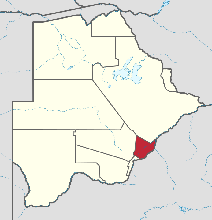
Kgatleng is one of the districts of Botswana, coterminous with the homeland of the Bakgatla people. Its capital is Mochudi, the hometown of protagonist Precious Ramotswe in Alexander McCall Smith's popular The No. 1 Ladies' Detective Agency series. According to the 2001 Census, Kgatleng had a population of 73,507 people. Kgatleng borders the North West Province of South Africa in the south, and to the east it borders South Africa's Limpopo Province. Domestically, it borders South-East District in southwest, Kweneng District in the west, Central District in north. The tourist and game reserves in the region are Oodi Weavers and Matsieng footprints. As of 2011, the total population of the district was 91,660 compared to 73,507 in 2001. The growth rate of population during the decade was 2.23. The total number of workers constituted 25,130 with 13,278 males and 11,853 females, with a majority involved in agriculture. The district is administered by a district administration and district council which are responsible for local administration. The district has no sub-districts.
Geography
Kgatleng borders the North West Province of South Africa in the south, and to the east it borders South Africa's Limpopo Province. Domestically, it borders South-East District in southwest, Kweneng District in the west, Central District in north. Most part of Botswana has tableland slopes sliding from east to west. The region has an average elevation of around 915 m (3,002 ft) above the mean sea level. The vegetation type is Savannah, with tall grasses, bushes and tress. The annual precipitation is around 55 cm (22 in), most of which is received during the summer season from November to May. Most of the rivers in the region are seasonal which are prone to flash floods, being the most prominent. The tourist and game reserves in the region are Oodi Weavers and Matsieng footprints.
Demographics
As of 2011, the total population of the district was 91,660 compared to 73,507 in 2001. The growth rate of population during the decade was 2.23. The population in the district was 4.53 per cent of the total population in the country. The sex ratio stood at 94.63 for every 100 males, compared to 94.60 in 2001. The average house hold size was 2.96 in 2011 compared to 4.29 in 2001. There were 3,690 craft and related workers, 1,708 clerks, 6,031 people working in elementary occupation 457 Legislators, Administrators & managers 1,477 Plant & machine operators and assemblers, 741 professionals, 2,171 service workers, shop & market sales workers, 1,237 skilled agricultural & related workers 1,482 technicians and associated professionals, making the total work force to 19,167.
Education and Economy
As of 2011, there were a total of 038 schools in the district, with 1.70 per cent private schools. The total number of students in the Council schools was 13,882 while it was 562 in private schools. The total number os students enrolled in the district was 14,444 constituting 6,963 girls and 7,481 boys. The total number of qualified teachers was 621 with 486 females and 135 males. There were around 034 temporary teachers, 15 male and 49 female. There were a total of 0 untrained teachers in the district. As of 2006, 7,216 were involved in Agriculture, 1,264 in Construction, 3,362 in Education, 177 in Electricity & Water, 410 in Finance, 709 in Health, 658 in Hotels & Restaurants, 1,397 in Manufacturing, 057 in Mining and Quarrying, 554 in Other Community Services, 1,059 in Private Households, 2,598 in Public Administration, 1,014 in Real Estate, 952 in Transport & Communications and 3,703 in Wholesale & Retail Trade. The total number of workers constituted 25,130 with 13,278 males and 11,853 females. [5]
6. North East
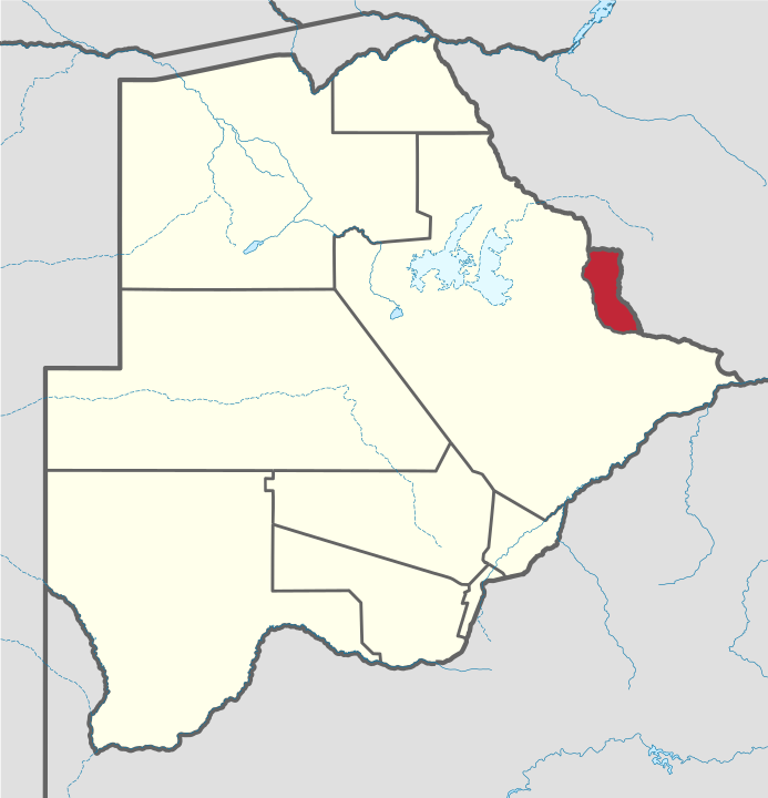
Its capital is Francistown. In 2013, North-East had a population of 167,500 people. The North-East District is predominantly occupied by Kalanga speaking people (the BaKalanga). In the north and east, North-East borders the Matabeleland South Province of Zimbabwe with the border in the east predominantly the Ramokgwebana River Center. In the south and west, North-East District borders Central District and the border being the Shashe River Center. The district is administered by a district administration and district council which are responsible for local administration. As of 2011, the total population of the district was 60,264 compared to 49,399 in 2001. The growth rate of population during the decade was 2.01. The total number of workers constituted 14,633 with 7,134 males and 7,498 females.
Geography
Most part of Botswana has tableland slopes sliding from east to west. The region has an average elevation of around 915 m (3,002 ft) above the mean sea level. The vegetation type is Savannah, with tall grasses, bushes and tress. The annual precipitation is around 65 cm (26 in), most of which is received during the summer season from November to May. Most of the rivers in the region are seasonal, with Limpopo River, which are prone to flash floods, being the most prominent.[2] There are conflicts between agricultural expansion and protection of indigenous wildlife within the Central District. There are several seasonal rivers in the district which flows in the rainy season reach the Makgadikgadi Pans. The Nata River flows through the North-East District and is a significant gathering place for wildlife including birds. The Nata River continues to flow to the Makgadikgadi Pans, where it discharges.
Demographics
As of 2011, the total population of the district was 60,264 compared to 49,399 in 2001. The growth rate of population during the decade was 2.01. The population in the district was 2.98 per cent of the total population in the country. The sex ratio stood at 90.30 for every 100 males, compared to 88.29 in 2001. The average house hold size was 3.11 in 2011 compared to 4.55 in 2001. There were 2,426 craft and related workers, 593 clerks, 3,485 people working in elementary occupation 273 Legislators, Administrators & managers 660 Plant & machine operators and assemblers, 331 professionals, 1,247 service workers, shop & market sales workers, 444 skilled agricultural & related workers 730 technicians and associated professionals, making the total work force to 10,243.
Education and Economy
As of 2011, there were a total of 66 schools in the district, with 6.70 per cent private schools. The total number of students in the Council schools was 24,296, while it was 1,277 in private schools. The total number of students enrolled in the district was 25,572: 12,564 girls and 13,008 boys. The total number of qualified teachers was 1,058, 841 female and 217 male. There were around 34 temporary teachers, 19 male and 53 female. There were no untrained teachers in the district.[7] As of 2006, 6,881 were involved in agriculture, 1,529 in construction, 1,161 in education, 73 in electricity and water, 61 in finance, 288 in health, 187 in hotels and restaurants, 434 in manufacturing, 784 in mining and quarrying, 97 in other community services, 206 in private households, 1,211 in public administration, 271 in real estate, 156 in transport and communications, and 1,294 in wholesale and retail trade. The total number of workers was 14,633, 7,134 male and 7,498 female.
Administration
Francistown Subdistrict and North East Subdistrict are the two sub-districts in the North-East District. In the 2011 Census forty-three villages were listed for the district: Botalaote, Butale, Ditladi, Gambule, Gulubane, Gungwe, Jackalas 1, Jackalas No 2, Kalakamati, Kgari, Letsholathebe, Mabudzane, Makaleng, Mambo, Mapoka, Masingwaneng, Masukwane, Masunga, Maitengwe, Matopi, Matshelagabedi, Matsiloje, Mbalambi, Moroka, Mosojane, Mowana, Mulambakwena, Nlakhwane, Patayamatebele, Pole, Ramokgwebana, Sechele, Sekakangwe, Senyawe, Shashe Bridge, Siviya, Tati Siding, Themashanga, Toteng, Tsamaya, Tshesebe, Vukwi and Zwenshambe. [6]
7. Ngamiland
For census and administrative purposes Ngamiland is subdivided into Ngamiland East, Ngamiland West and Ngamiland Delta (Okavango). It is governed by a District Commissioner, appointed by the national government, and the elected North-West District Council. The administrative centre is Maun. As of 2011, the total population of the district was 175,631 compared to 142,970 in 2001. The growth rate of population during the decade was 2.08. The total number of workers constituted 32,471 with 16,852 males and 15,621 females, with a majority of them involved in agriculture. Maun, the Tsodilo Hills, the Moremi Game Reserve, the Gchwihaba (Drotsky's) Caves, the Aha Hills (on the border with Namibia), the Nhabe Museum in Maun, and Maun Educational Park are the major tourist attractions in the district.
Geography
The region has an average elevation of around 915 m (3,002 ft) above the mean sea level. The vegetation type is Savannah, with tall grasses, bushes and trees. The annual precipitation is around 650 mm (26 in), most of which is received during the summer season from November to May. North-West District shares its borders with the following foreign areas: Omaheke Region, Namibia in southwest, Otjozondjupa Region, Namibia in west, Kavango East Region, Namibia in northwest and Zambezi Region, Namibia in north. Domestically, it borders Central District in southeast, Ghanzi District in southwest and Chobe District in the east. Like most of Botswana, it consists of partially dissected tablelands, in this case sloping down from the Kaukau Veld that lies to the northwest.[8] This flow and the Okavango River drain into the mostly endorheic Okavango Delta. The delta seasonally overflows into the endorheic Lake Ngami to the south, and into the Thamalakane River which via the Boteti River feeds the Makgadikgadi salt pans to the southeast. Most of the rivers in the region are seasonal, and subject to flash floods.[10] Maun, the Tsodilo Hills, Moremi Game Reserve, Gchwihaba (Drotsky's) Caves, Aha Hills, Nhabe Museum and Maun Educational Park are the major tourist attractions in the district.
Demographics
As of 2011, the total population of the district was 175,631 compared to 142,970 in 2001. The growth rate of population during the decade was 2.08. The population in the district was 8.67 per cent of the total population in the country. The sex ratio stood at 95.11 for every 100 males, compared to 93.43 in 2001. The average house hold size was 3.27 in 2011 compared to 4.49 in 2001. There were 5,437 craft and related workers, 2,290 clerks, 8,777 people working in elementary occupation 1,117 Legislators, Administrators & managers 2,974 Plant & machine operators and assemblers, 856 professionals, 5,812 service workers, shop & market sales workers, 2,398 skilled agricultural & related workers 2,069 technicians and associated professionals, making the total work force to 31,915.
Education and Economy
As of 2011, there were a total of 071 schools in the district, with 8.30 per cent private schools. The total number of students in the Council schools was 28,101, while it was 940 in private schools. The total number of students enrolled in the district was 29,041: 14,190 girls and 14,851 boys. The total number of qualified teachers was 1,070, 658 female and 412 male. There were around 27 temporary teachers, 13 male and 40 female. There were 6 untrained teachers in the district.[12] As of 2006, 12,737 were involved in agriculture, 1,131 in construction, 2,090 in education, 177 in electricity and water, 88 in finance, 1,000 in health, 1,144 in hotels and restaurants, 1,450 in manufacturing, 403 in other community services, 1,455 in private households, 4,722 in public administration, 932 in real estate, 730 in transport and communications, and 4,412 in wholesale and retail trade. The total number of workers was 32,471, 16,852 male and 15,621 female.
Administration
By far the largest settlement in the district is Maun, which had a population of over 60,000 in 2011 census. The following is the list of villages noted separately in the 2001 census in each census region. Ngamiland East has Bodibeng, Botlhatlogo, Chanoga, Habu, Kareng, Kgakge/Makakung, Komana, Mababe, Makalamabedi, Matlapana, Maun, Phuduhudu, Sehithwa, Semboyo, Sankuyo, Shorobe, Toteng, Tsao villages. Ngamiland West has Beetsha, Etsha 6, Etsha 13, Gani, Gonutsuga, Gumare, Ikoga, Kauxwhi, Mohembo East, Mohembo West, Mokgacha, Ngarange, Nokaneng, Nxamasere, Nxaunxau, Qangwa, Sepopa, Seronga, Shakawe, Tobere, Tubu, Xakao, Xaxa, Xhauga villages. Delta region has Daonara, Ditshiping, Jao, Katamaga, Morutsha, Xaxaba villages. In the 2011 census the population figures for the delta were included in the totals of Ngamiland East. When Botswana gained independence from the British in 1966, they adapted the colonial administration framework to form its district administration. The policies were modified between 1970 and 1974 to address impediments to rural development. The district administration, a district council, and the Okavango subdistrict council are responsible for local administration. The policies for the administration are framed by the Ministry of Local Government. The major activities of the district council are Tribal Administration, Remote Area Development and Local Governance. The executive powers of the council are vested in a commissioner appointed by the central government. The technical services wing of the Department of Local Government is responsible for developing roads and the infrastructure in villages such as water supply, schools and recreational facilities. All local administration staff, except the District Administration staff itself, are selected via centralised services of the North West District Council, with the Ministry of Local Government being responsible for their training, deployment and career development. The sub-districts of North-West/Ngamiland District are Ngamiland East (aka Ngamiland South, headquarters Maun), Ngamiland West (aka Ngamiland North) and Okavango, also called Ngamiland Delta, (headquarters Gumare). [7]
8. Kgalagadi
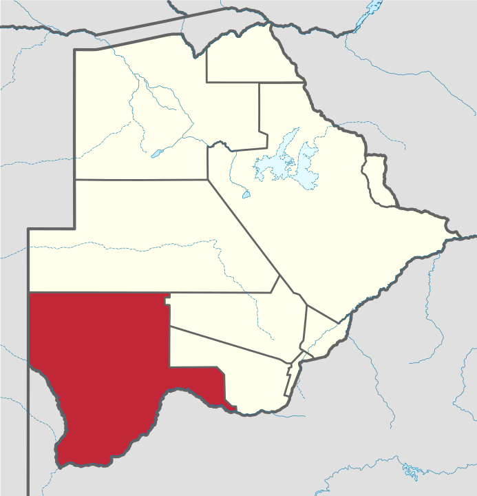
Kgalagadi is a district in southwest Botswana, lying along the country's border with Namibia and South Africa. The administrative center is Tsabong. The district of Kgalagadi covers a large part of the Kalahari Desert. It has a total area of 105,200 km² and has a population of 42,000 (2001). More than one-third of the district is covered by the Kgalagadi Transfrontier Park, which extends into South Africa, and which is a major tourist attraction. As of 2011, the total population of the district was 50,492 (compared to 42,049 in 2001). The growth rate of population during the decade was 1.85. Kgalagadi's population represents 2.49 per cent of the total population of Botswana. The majority of employees (in 2011 there were 10,530 people in work) were working within the transport & communication and public administration sectors. The district is administered by a district administration and district council
Geography
Kgalagadi borders Omaheke Region, Namibia in the northwest, Hardap Region, Namibia in the southwest, Northern Cape Province, South Africa in the south, North West Province, South Africa in the southeast and omestically, Ghanzi District in the north, Kweneng District in the northeast, and Southern District in the east. Kgalagadi means "land of the thirst". The largest settlement in the district is Tsabong, which had a population of 8939 in 2011 census while Hukuntsi and Kang had 4654 and 5985, respectively. Most part of Botswana has tableland slopes sliding from east to west. The region has an average elevation of around 915 m (3,002 ft) above the mean sea level. The vegetation type is Savannah, with tall grasses, bushes and trees. The annual precipitation is around 25 cm (9.8 in), most of which is received during the summer season from November to May. Most of the rivers in the region are seasonal, with Limpopo River, which are prone to flash floods, being the most prominent. The tourist and game reserves in the region are Ghanzi, Central Kalahari Game Reserve, Deception Valley, Ghanzi Craft, Kgalagadi Transfrontier Park, Khutse Game Reserve and Kuru Museum and Cultural Centre.
Demographics
As of 2011, the total population of the district was 50,492 compared to 42,049 in 2001. The growth rate of population during the decade was 1.85. The population in the district was 2.49 per cent of the total population in the country. The sex ratio stood at 101.78 for every 100 males, compared to 101.18 in 2001. The average house hold size was 3.12 in 2011 compared to 4.31 in 2001. There were 1,576 craft and related workers, 628 clerks, 4,039 people working in elementary occupation 256 legislators, administrators and managers 614 Plant & machine operators and assemblers, 266 professionals, 1,278 service workers, shop and market sales workers, 1,309 skilled agricultural and related workers 771 technicians and associated professionals, making the total work force to 10,770.
Education and Economy
As of 2011, there were a total of 41 schools in the district, with no private schools. The total number of students in the Council schools was 8,869 while there were none in private schools. The total number of students enrolled in the district was 8,869: 4,211 girls and 4,658 boys. The total number of qualified teachers was 445, 315 female and 130 male. There were around 13 temporary teachers, 10 male and 23 female. There were no untrained teachers in the district. As of 2006, 3,353 were involved in agriculture, 294 in construction, 774 in education, 86 in electricity and water, 32 in finance, 344 in health, 375 in hotels and restaurants, 413 in manufacturing, 91 in other community services, 842 in private households, 1,880 in public administration, 195 in real estate, 65 in transport and communications, 1,786 in wholesale and retail trade. The total number of workers was 10,530: 6,334 male and 4,195 female
Administration
The sub-districts of Kgalagadi District created as a part of National Development Park of the district are Kgalagadi North and Kgalagadi South. Kgalagadi South has the following villages: Bogogobo, Bokspits, Bray, Gachibana, Khisa, Khuis, Khwawa, Kokotsha, Kolonkwane, Makopong, Maleshe, Maralaleng, Maubelo, Middlepits, Omaweneno, Phepheng (Draaihoek), Rapples Pan, Struizendam, Tsabong, Vaalhoek, Werda. Kgalagadi North has the following villages: Hukuntsi, Hunhukwe, Inalegolo, Kang, Lehututu, Lokgwabe, Make, Monong, Ncaang, Ngwatle, Phuduhudu, Tshane, Ukwi, Zutswa. [8]
9. Chobe
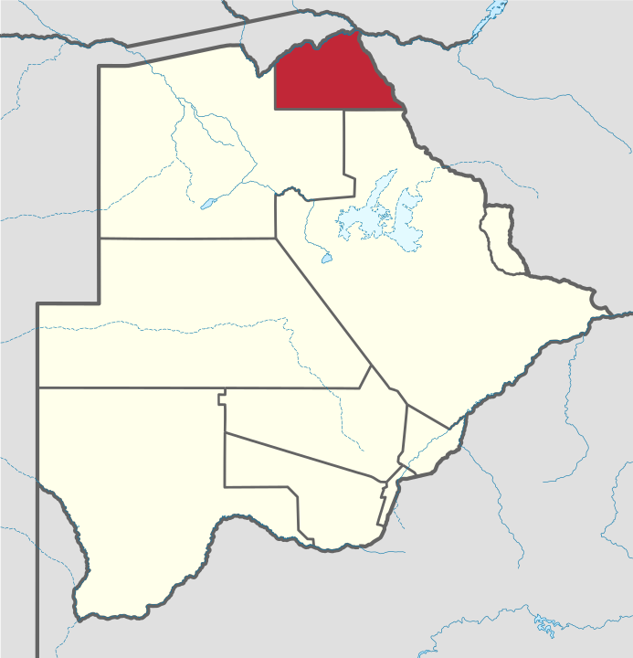
Chobe District is an administrative district in the northern part of Botswana, with the headquarters in Kasane. In 2001 it was merged with Ngamiland, and until 2006 it shared with Ngamiland the North-West District Council as local government. Chobe National Park is in the Chobe District. As of 2011, the total population of the district was 23,347 compared to 18,258 in 2001. The growth rate of population during the decade was 2.49. The total number of workers constituted 12,059 with 6,113 males and 5,947 females, with majority of them working in public administration. Kasane and Chobe National Park, the second largest national park in the country, are the major tourist attractions in the district. Chobe National Park also has the largest population of elephants in Africa. The district shares the international border of the country with Namibia and Zambia in the north, Zimbabwe in the east, and also the district borders along North-West district of the country. Chobe district was established during July 2008 and is not sub-divided.
Geography
Kasane, Chobe National Park, Seboba Water Rapids, Pandamatenga Farms, Lesoma Memorial Monument, Kasane Hot Springs and Chobe River are the major tourist attractions in the district. Most part of Botswana has tableland slopes sliding from east to west. The region has an average elevation of around 915 m (3,002 ft) above the mean sea level. The vegetation type is Savannah, with tall grasses, bushes and trees. The annual precipitation is around 65 cm (26 in), most of which is received during the summer season from November to May. Most of the rivers in the region are seasonal, with Chobe River, which are prone to flash floods, being the most prominent. Chobe National Park is the second largest national park in the country and has the largest population of elephants in Africa. The district shares the international border of the country with Namibia and Zambia in the north, Zimbabwe in the east, and also the district borders along North-West district of the country.
Demographics
As of 2011, the total population of the district was 23,347 compared to 18,258 in 2001. The growth rate of population during the decade was 2.49. The population in the district was 1.15 per cent of the total population in the country. The sex ratio stood at 106.17 for every 100 males, compared to 106.00 in 2001. The average house hold size was 2.45 in 2011 compared to 3.60 in 2001. There were 943 craft and related workers, 573 clerks, 2,053 people working in elementary occupation 186 legislators, administrators and managers, 1,083 plant and machine operators and assemblers, 128 professionals, 1,377 service workers, shop and market sales workers, 243 skilled agricultural and related workers, and 296 technicians and associated professionals, making the total work force 6,888.
Education and Economy
As of 2011, there were a total of 11 schools in the district, with 1.70 per cent private schools. The total number of students in the Council schools was 3,217 while it was 64 in private schools. The total number of students enrolled in the district was 3,281: 1,587 girls and 1,694 boys. The total number of qualified teachers was 154, 98 female and 56 male. There were around 16 temporary teachers, 6 male and 22 female. There was 1 untrained teacher in the district. As of 2006, 1,260 were involved in Agriculture, 322 in Construction, 236 in Education, 76 in Electricity & Water, 095 in Finance, 070 in Foreign Mission, 236 in Health, 510 in Hotels & Restaurants, 314 in Manufacturing, 107 in Private Households, 1,743 in Public Administration, 194 in Real Estate, 185 in Transport & Communications, and 681 in Wholesale & Retail Trade. The total number of workers constituted 12,059 with 6,113 males and 5,947 females. [9]
10. Ghanzi District
Ghanzi (sometimes Gantsi) is a district in western Botswana, bordering Namibia in the west and extending east into much of the interior of the country. The district's administrative centre is the town of Ghanzi. Most of the eastern half of Ghanzi makes up the Central Kalahari Game Reserve. The human population at the 2001 census was 43,370, less populous than that of any other district in Botswana. Ghanzi's area is 117,910 km². In the west, Ghanzi borders the Omaheke Region of Namibia. Domestically, it borders the following districts: North-West on the north, Central on the east, Kweneng on the southeast, Kgalagadi on the south. Ghanzi, Central Kalahari Game Reserve, Deception Valley, Ghanzi Craft, Kgalagadi Transfrontier Park and Khutse Game Reserve are the major game areas in the district. The district is administered by a district administration and district council which are responsible for local administration. The total number of workers constituted 10,294 with 5,959 males and 4,335 females, with agriculture as the major occupation. Charles Hill Sub-District, Ghanzi Sub-District are the two sub districts of the district.
Geography
In the west, Ghanzi borders the Omaheke Region of Namibia. Domestically, it borders the following districts: North-West on the north, Central on the east, Kweneng on the southeast, Kgalagadi on the south. Ghanzi is traversed by the northwesterly line of equal latitude and longitude. This region is largely covered by the Kalahari Desert, some of which is also covered by the Makgadikgadi Pans, a large seasonal wetland. The Makgadigadi was one of the Earth's largest lakes during the Pleistocene, but currently provides a vast summer wetland to support tens of thousands of migrating flamingos in the rainy summer season. The largest village in the district is the capital Ghanzi with a population of 9,934 according to the 2001 census, which is five times more than the second-largest village Ncojane has. Most part of Botswana has tableland slopes sliding from east to west. The region has an average elevation of around 550 m (1,800 ft) above the mean sea level. The vegetation type is Savannah, with tall grasses, bushes and trees on the eastern sides, but it is arid in the Central and Western regions. The annual precipitation is around 25 cm (9.8 in), most of which is received during the summer season from November to May. Most of the rivers in the region are seasonal which are prone to flash floods, being the most prominent. The tourist and game reserves in the region are Ghanzi, Central Kalahari Game Reserve, Deception Valley, Ghanzi Craft, Kgalagadi Transfrontier Park, Khutse Game Reserve and Kuru Museum and Cultural Centre.
Demographics
As of 2011, the total population of the district was 43,355 compared to 33,170 in 2001. The growth rate of population during the decade was 2.71. The population in the district was 2.14 per cent of the total population in the country. The sex ratio stood at 107.41 for every 100 males, compared to 104.07 in 2001. The average house hold size was 2.94 in 2011 compared to 4.21 in 2001. There were 1,424 craft and related workers, 615 clerks, 3,730 people working in elementary occupation 230 Legislators, Administrators & managers 534 Plant & machine operators and assemblers, 131 professionals, 1,043 service workers, shop & market sales workers, 771 skilled agricultural & related workers 509 technicians and associated professionals, making the total work force to 9,015.
Education and Economy
As of 2011, there were a total of 23 schools in the district, with 1.70 per cent private schools. The total number of students in the Council schools was 7,202 while it was 69 in private schools. The total number of students enrolled in the district was 7,271: 3,645 girls and 3,626 boys. The total number of qualified teachers was 305: 185 female and 120 male. There were around 17 temporary teachers, 17 male and 34 female. There were no untrained teachers in the district. As of 2006, 3,507 were involved in agriculture, 323 in construction, 724 in education, 43 in electricity and water, 121 in finance, 264 in health, 83 in hotels and restaurants, 560 in manufacturing, 93 in other community services, 399 in private households, 1,849 in public administration, 355 in real estate, 185 in transport and communications, 1,788 in wholesale and retail trade. The total number of workers was 10,294: 5,959 male and 4,335 female. [10]
REFERENCES
[2] https://en.wikipedia.org/wiki/Kweneng_District
[3] https://en.wikipedia.org/wiki/Southern_District_(Botswana)
[4] https://en.wikipedia.org/wiki/Central_District_(Botswana)
[5] https://en.wikipedia.org/wiki/Kgatleng_District
[6] https://en.wikipedia.org/wiki/North-East_District_(Botswana)
[7] https://en.wikipedia.org/wiki/North-West_District_(Botswana)
[8] https://en.wikipedia.org/wiki/Kgalagadi_District
[9] https://en.wikipedia.org/wiki/Chobe_District
[10] https://en.wikipedia.org/wiki/Ghanzi_District